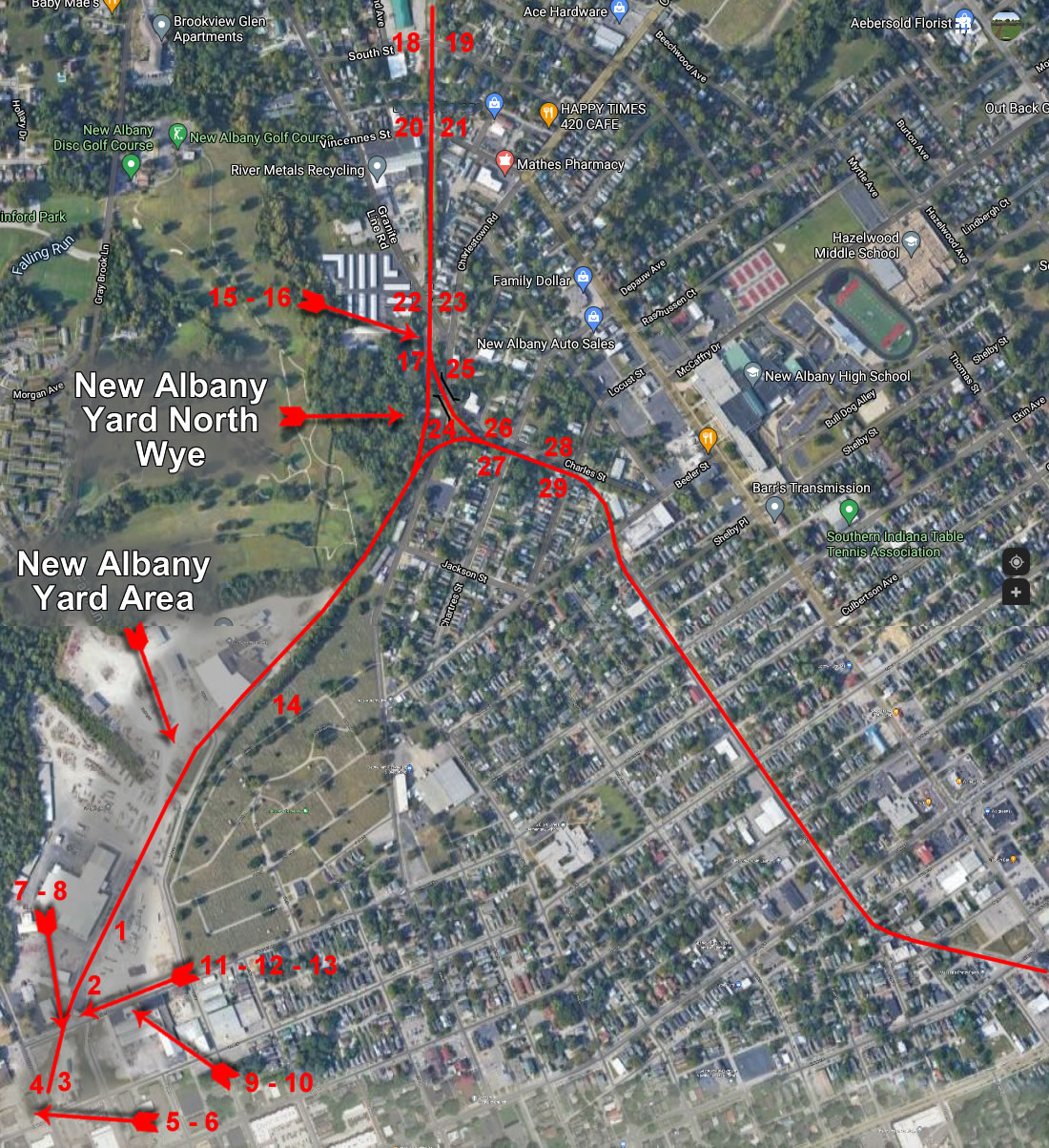
Google map 2021
New Albany Yard Area
Nathan Miles Photos 2021
MONON Railroad in red
Click on the number on
the map to see the picture of that area.
Descriptions are to the right.
| Back |
1: An overview of the yard area. There's almost nothing left. Looking toward the mainline.
2: The approximate location of the freight house. Looking toward the mainline.
3: The location of the New Albany and Salem's original passenger station/freight station/repair shop/locomotive factory. One convenient location, for all your railroad needs. Looking away from the mainline.
4: This pile of crumbling rock once held up a track running along the side of the depot/shops. Looking away from the mainline.
5: This building is also original to the New Albany and Salem, possibly their first corporate offices. And it's for sale, if anyone (MRHTS?) wants to own this piece of history.
6: Another angle of the New Albany and Salem offices, showing the back.
7: Taken from the Culbertson Avenue crossing. Looking toward the mainline.
8: The Culbertson Avenue crossing. Looking away from the mainline.
9: The remains of a siding running alongside the former Anchor Stove and Range Company. Looking away from the mainline.
10: The remains of a siding running into the former Anchor Stove and Range Company. Looking away from the mainline.
11: This caboose sits at the entrance to the Padgett facility, and marks the location of the founding of the New Albany and Salem. It's not ex-Monon, actually being WAB2742, but it's a nice sentiment.
12: Right next to the caboose is this historical marker.
13: Back side of the historical marker.
14: The gravesite of James Brooks in Fairview Cemetery, fittingly only about 200 feet from the railroad he founded. Yellow daisies courtesy of me.
15: The remains of the yard lead, branching off from the mainline just north of Grant Line Road. Looking away from the mainline.
16: A close up of part of the yard lead. There are still a couple rails lying around.
17: Looking across Bridge 316.7, which also happens to be the southernmost bridge the Monon owned. Looking south toward Louisville.
18: Taken from the South Street crossing. Looking north toward Chicago.
19: The South Street crossing. Looking south toward Louisville.
20: Taken from the Vincennes Street crossing. Looking north toward Chicago.
21: The Vincennes Street crossing. Looking south toward Louisville.
22: Taken from the Grant Line Road crossing. Looking north toward Chicago.
23: The Grant Line Road crossing. Looking south toward Louisville.
24: Taken from below the East Eighth Street overpass. Looking north.
25: Below the East Eighth Street overpass. Looking south.
26: Taken from the Charles Street crossing. Looking north toward Chicago.
27: The Charles Street crossing. Looking south toward Louisville.
28: Taken from the Locust Street crossing. Looking north toward Chicago.
29: The Locust Street crossing. Looking south toward Louisville.