
M.P. I&L F 29.5 - 6th Subdivision -
The name Martz came from the town's founder, Arthur Martz in 1827. An alternate name was also used at one point by local residents, Middleberry, which was selected from a book. The second name was also attributed to another founder of the town, John Cooprider in 1836. Unfortunately there was already a town and post office established in Elkhart County called Middleberry. The elevator was the largest non-coal facility on the I&L Branch and during grain season provided a steady flow of traffic.


Left and Right: Building the elevator at Martz, early 1950's.


Additional pictures of the elevator at Martz.
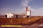

Martz,
Indiana. Left: Fertilizer company, circa 1979. Right: Typical rural Indiana
scene. The elevator at Martz, also 1979.
 Great
shot of a freight about to cross the Eel River on the I&L Branch, May
1971.
Great
shot of a freight about to cross the Eel River on the I&L Branch, May
1971.
Martz area 2019
Pictures by Nathan
Miles
click on map to view all pictures by number


M.P. I&L F 35.0 - 6th Subdivision -


Welcome
to Howesville. Left: Old fertilizer company along the mainline, circa 1979.
Right: The mainline through Howesville. Not sure whether it is looking
north or south.
Peabody Coal Spur
The Monon as well as the Milwaukee
Road served the Peabody Coal Company. The Monon reached the tipple via
a spur line that started at the wye a few miles north of Midland. The
Milwaukee Road from the other direction near the Latta yard. Coal was
a major source of revenue on the Monon.
 Midland
Turn, Peabody spur line, long range view, circa 1971.
Midland
Turn, Peabody spur line, long range view, circa 1971.


Left and Right:
Two more images from the Midland Turn and the Peabody spur. Again, circa
July 1971. These images were taken from the Monon Railroad Historical
-Technical Society's Ron Marquardt Image CD. Please help support
the preservation of the history and the legacy of the Monon Railroad
and purchase a copy today.


Left: Pushing
empties at the Peabody tipple, May 1971. Right: Peabody Coal Company
cars at the tipple, May 1971.
 #501 on the point of a freight on the I&L branch, circa 1971.


Left and Right: The tracks leading to
the old Peabody miller creek tipple. These tracks are located just east
of the
Latta yard curving around to the east and crossing Highway 59 north to Jasonville.
 Grade crossing at Highway 59.

Outside of Midland on the I&L Branch. A coal truck hit the bridge, knocked the track out of line, and a train derailed when it went over the bad spot. The RS2 that was on the train ended up crosswise on the main. The two workers pictured are Jenks Grubbs and Red Lattimer.

RS 2 sitting sideways on the mainline.

M.P. IL42.0 - 6th Subdivision - NA
The town of Midland, Indiana, was an outside point on the Monon Railroad.
It was never a major facility, but it was the terminus of Monon's coal mine
spurs in Green and Sullivan County, and the focus of the many varied activities
associated with making up coal trains for shipment to other points along
the Monon Route. At one time, there were as many as twelve train crews stationed
at Midland. In 1918, when the Midland yard was just six years old, it had
to be expanded to accomodate the increases in freight traffic. At one point
in time there were as many as thirty-four coal mines feeding into the Midland
yards.

Looking into the yard at Midland. The year is 1913.

Looking into the enginehouse at Midland. Unknown date. -Lloyd Kimble Collection-
The round house had four stalls, but lacked a turntable or
wye. They had to do all their turning either at Vicksburg, or by using several
switches. South of the depot was what they used to call the 'beanery'. (Officially,
the YMCA dormitory, according to Monon records.) The beanery was a big long
building near the throat of the the south yards. Adjacent to the dormitory
were separate buildings housing the restaurant, complete with a sixteen foot-long
sign on top of the roof, and a small
residence for its operator.


Left: One of the Monon's Company houses. Based on its
size, it appears to be
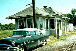
the one designated for the restaurant operator. Right: Midland depot, date unknown.


Left and Right Above and Below: Derailment at Midland, November 30, 1959 near the Friar Tuck Mine. Northbound freight out of Midland struck semi track resulting in the derailment. The Monon Coal Company leased mining rights to Sherwood Templeton Coal Company. They leased vein #6 to Sherwood Templeton in August of 1945. They sold vein #7 to Sherwood Templeton in 1949. Both eventually became Peabody #48 Tract. They also operated Robin Hood Mine and Friar Tuck on the C.M. & St. P RR. -Hulcee Martin Photos, Martin Family Collection-


Another picture of the clean up of the derialment near the Friar Tuck Mine. -Hulcee Martin Photos, Martin Family Collection-


Left: Boxcar building at Midland, early 1950's. Right: Diesel facillities at Midland.

Left: Midland Depot, circa 1970's. Right: Boxcar shed and sanding towers, Midland. -Dave Ritenour photos.-

Freight waits at the depot. C-420 516 is in the lead. -Dave Ritenour Photo.-


Action on the I&L Branch, circa 1971. Left: Monon local freight
passing the depot at Midland. Right: Local working the yard in Midland.
 November
1979. Old Monon depot at Midland Junction.
November
1979. Old Monon depot at Midland Junction.


Two views of the former junction at
Midland. Left: March 1966. Monon Junction with the CMstP&P. You are looking
toward
the
south.
The yard office is to the left. Right: Almost the same view, ten years later,
October 1976.
 The
tower at Midland Junction. Looking towards the south.
The
tower at Midland Junction. Looking towards the south.
 November
1979. The former Monon crossing. CMStP&P
GP 20 #977 working the line.
November
1979. The former Monon crossing. CMStP&P
GP 20 #977 working the line.
Midland Area 2006
Scott Wellington BMIA operative has
been wandering the former line near Midland and the mines that the Monon
once served. He has provided these pictures and hopes in the near future
to send more.

Left and Right: These pictures were taken near a grade crossing
near County Road 700 at Midland. Some tracks are still in place.
 Grade
crossing signal at County Road 700. As you can see, time has taken its
toll.
Grade
crossing signal at County Road 700. As you can see, time has taken its
toll.

Midland area 2019
Pictures by Nathan
Miles
click on map to view all pictures by number


 Greene
Valley Mine, Jasonville, Indiana. Date unknown. Interesting picture. On
checking on mines served by the Monon, I could not find a listing
for Greene Valley Mine. Green Valley No.1. Green Valley Coal Company. 127
feet deep. 5.2 foott coal vein. Mined 3,331.000 tons Operated
1902-1924.
Greene
Valley Mine, Jasonville, Indiana. Date unknown. Interesting picture. On
checking on mines served by the Monon, I could not find a listing
for Greene Valley Mine. Green Valley No.1. Green Valley Coal Company. 127
feet deep. 5.2 foott coal vein. Mined 3,331.000 tons Operated
1902-1924.
The location was on the east side of SR48 directly
across from the Shakamak State Park entrance.

Nortwest Mine, Jasonville, circa 1911. This mine was more than likely served by the Monon.


Jasonville
was just north of Midland yard. It was not part of the Monon but Peabody
Coal Company had a shop
their
for their
railroad operations. Left: Peabody Coal Company's Miller Tipple. Right: Fertilizer
plant along the Jasonville tracks. Both photographs, circa 1979.
 Clean
Up On Track One! Part of the Wye track at Miller's Tipple. This was the
connection
with the Monon. Looks like they
had a slight accident, November 12, 1979.
Clean
Up On Track One! Part of the Wye track at Miller's Tipple. This was the
connection
with the Monon. Looks like they
had a slight accident, November 12, 1979.

 Latta
also was not on the Monon but close by. It was the Milwaukee Road
Yard for the coal mines in the area.
Latta
also was not on the Monon but close by. It was the Milwaukee Road
Yard for the coal mines in the area.

M.P. I&L F 47.1 - 6th Subdivision -
 The
S&A Coal Corporation's new coal washer and tipple, circa
1955. Completion of this structure, in 1954, gave the railroad renewed hope
for revenue on the I&L Branch. Pictured are Monon hoppers ready for loading.
The structure would be fed by coal from area strip mines.
The
S&A Coal Corporation's new coal washer and tipple, circa
1955. Completion of this structure, in 1954, gave the railroad renewed hope
for revenue on the I&L Branch. Pictured are Monon hoppers ready for loading.
The structure would be fed by coal from area strip mines.
 Another
look at the coal washer and tipple at Victoria. CIL hopper #40180 and others
wait to be filled.
Another
look at the coal washer and tipple at Victoria. CIL hopper #40180 and others
wait to be filled.
| Mines
On The Monon |
| Bygone Monon Main |
Sixth Subdivision |


