|
7th Subdivision - French Lick Branch Since Orleans had no servicing facilities for the train, the French Lick locals originated at Bedford. The French Lick Branch left the mainline at Orleans. The French Lick Branch traces its beginning back to 1885. Originally organized as the Orleans, Paoli and Jasper Railway, the plan was to build a railroad from Orleans to the town of Jasper, about 50 miles away. Since the LNA&C passed through Orleans and on the OP&J's board were several LNA&C officials, it seemed a natural that a branch line was in the future. The days of the OP&J were brief. Within a year the company was purchased by the LNA&C and renamed the Orleans, West Baden & French Lick Springs Railway. Several factors made this move attractive, including passengers, lumber, stone and coal. Also the resorts at French Lick and West Baden were just forming into well know resorts, becaue of the "Pluto Water". Beyond French Lick, towards Jasper lay field of bituminous coal. By July 1988 the work on the OWB&FLS had begun. The line was completed to French Lick in the summer of 1887 and service began in August. The OWB&FLS was marked with a number of small trestles, grades of 1.76% and one dominate feature, a curving 1600 foot trestle over Lost River north of Paoli. The line was never completed south of French Lick. The Southern Railway completed the line and a connection with the Monon was complete in 1908.
M.P. 261.5 - 5th Subdivision - Ns
The back of the ? depot. Oh wait, the roof tells it all. This was a common practice. -Lloyd Kimble Collection-
Left: Another view of local freight coming off the French Lick branch. Right: End of train at Orleans coming off the French Lick Branch.
Two views of the Orleans depot. -Dick Fontaine Photographs-
French Lick passenger at Orleans. August 3, 1949. RS2 #24 on Train #23 is backing up to head around the wye. The train is on the main and headed south. Train #23 would come in from Bloomington, stop at the depot to load and unload, then back up a little bit and head through the crossover down the French Lick branch. -Charles Herley Photograph, MRHTS Photo Archives Collection-
French Lick branch right of way, 2005. Left: This section of the right of way is south of Orleans at the County Road 575 crossing, looking north. Right: In this view you are looking south from the same location. -Images courtesy Justin Asbery-
Old ROW, now a driveway, looking back towards Orleans. -Justin Asbery Photos-
Left: Looking north up the old ROW towards Orleans. Right: On the old ROW betweeen two county roads but north of the sawmill facing south toward Paoli. -Justin Asbery Photos-
Left: Looking north from the County Road 500 crossing south of Orleans. The mound which you may be able to make out is the remains of an old saw mill. Right: Looking south from the same location as the picture on the left. -Images courtesy Justin Asbery-
MP D 4.0 7th Subdivision
Wreck on the French Lick Branch at Lost River. Locomotive #518 turned over.
These pictures were taken along Lost River Road. Left: Looking north along the right of way. In the distance are some bridge abutments. Right: Looking south along the right of way from the same location. -Images courtesy Justin Asbery-
The former Monon French Lick Branch right of way, north of Paoli. Left: Looking railroad north up the old right of way about a half mile north of the Paoli Trestle. Right: Most of the right of way south towards the north abutment of the Paoli Trestle can be walked. Pictured about is looking down the right of way. It is hard to see in this image, but the trestle starts about 15-20 yards beyond this location. In winter it would be easier to see the end of the right of way.
Left: Looking south along the old right of way, at the end is the north abutment. Right: Looking back north along the old right of way. Last fall during the Monon Convention, Justin and I were able to walk down the line to where the fence is in the picture. This day Justin was able to get all the way to the north bridge abutment.
Bridge D 6.9
Northbound mixed train crossing the original 1600 foot curved wooden trestle north of Paoli. Dtae of the photo is unknown, but the trestle was built in 1886 and replaced with a steel bridge in 1904 -The Depot Collection Salem-
Left: Looking up the old 1887 right of way. You are looking north. Right: Another shot looking north along the 1887 right of way.
Left: Former 1887 Right of way north of wooden trestle, looking towards the north. Right: What remains of the wooden trestle's north bridge abutment.
Left: All around the general area of the north end of the old wooden bridge Justin found large quarried stones, which were supports for the woodent trestle bents. Right: Justin found what looks like an old quarry. Justin believes that this was once an old quarry where most of the stones for the abutments were cut. Here is an part of his journey..."I decided to hike over to the north abutment of the wooden trestle. I had to first find a way down the other side of the 1904 right of way. While the west side of the 1904 right of way was pretty much earth, the east side of the right of way was large pieces of cut limestone of various sizes. After salvaging one of the better spikes from the base of the 1904 north abutment, I crossed a fence on the other side and headed toward the 1887 right of way and the location of the old wooden trestle. I first came upon an old road. It looked more like an old logging trail. This road led down to the top rim of the old quarry, where I took the photo which you have posted. Then I continued walking east until I came across the stone footings that once supported the wooden trestle. Several stone had been removed, but the remaining ones were all in good shape, for being there 119 years. This is where I photographed the north abutment. I also then followed the old 1887 right of way and took the others pictures which you have posted. Hate to brag on about this but it sure was exciting!" - Justin Asbery BMIA Operative, May 17, 2006-
Left and Right: The south abutment of the wooden trestle north of Paoli, circa 2006. This structure is located east of the steel trestle pictured below.
Left: Looking up at the abutment. Justin Asbery advised that there are also many slabs where the trestle bents once were secured. Right: Looking railroad south along the old right of way, towards the relocated right of way.
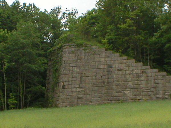
The French Lick Branch had one tremendous structure, the Paoli Trestle. The original structure was a curved 1600 foot wooden trestle over Lost River just north of town. In 1904 it was replaced with a steel structure as part of a line relocation. Left: Wooden heavyweights cross the trestle, pulled by a 4-6-0 in 1916. Right: 1947 inspection train crossing the trestle with Business Car # 90 on the end.
Left and Right: The Paoli Trestle.
Left: Chronicled as a passenger only line, the French Lick branch did provide a source of freight tonage as evidenced by this Monon freight crossing the trestle, date unknown. Right: Shot of the bridge after the Monon herald was adde to the side.
Left: Consist of RS2's pulling local freight across the Paoli Trestle, 1970. Right: The year is 1961. Local freight southbound with FM #45 and #46 in the lead.
Left and Right: Looking across the Trestle.
Looking south across the Paoli Trestle. From this angle it does not look that long.
The Paoli Trestle, circa 1970. Another great side view of the trestle.
Left and Right. L&N local freight crossing the Paoli Trestle.
Jim Craig sent me these photos of the demolition of the Paoli Trestle. Not much explanation is necessary. Building the trestle or tearing it down, it must have been a sight to behold. I envy those who got to see the bridge during the "days", or operate trains over this structure. It must have been an awesome experience.
Thanks to Jim for allowing me to add his great photos to this page.
May 2004. All that remains of the Paoli Trestle. Left: North bridge abutment. Right: South abutment. To appreciate what this structure once was, one must pay a visit to Paoli and see where it once spanned
Left: Looking across the former Paoli Trestle. Justin is standing near the end of the right of way at the north abutment. Right: Another view of the Lost River valley, once spanned by the trestle. Great photos Justin.
Panoramic view of the location. One could only imagine what it would be like to cross this trestle.
The north bridge abutment.
M.P. D 7.6 - 7th Subdivision - PL One could say Paoli gave birth to the entire state
of Indiana. That is because in 1805 the initial pivot point was established
just south of town to survey
all the boundaries in Indiana. The first settlement of Orange County happened
in Paoli’s Southeast
Township. In 1807 John Hollowell settled on the Patoka River near the present-day
community
of Valeene. It was another four years before any other significant settlements
moved across the county. Just as Indiana became a state, Paoli got its name. In 1816 it was derived from Pasquale Paoli Ash, the 12-year-old son of North Carolina’s governor at the time, and shortly thereafter chosen as the seat of justice for the county. With its strong religious ties, in 1833-34 the people of Paoli were the first to petition the county board to stop issuing liquor licenses. The courthouse square is the heart of downtown Paoli and boasts the largest shopping district in the county. With newly renovated brick-lined sidewalks, attractive period lighting and park benches, the downtown has been placed on the national register for historic places. -Courtesy Orange County, Indiana Website-
Welcome to Paoli. Circa 1947.
Dougherty's Spring Mill near Lick Creek Church, just off Highway 150. This mill was one of the first businesses in the area. -Orange County Historical Museum Collection-
Left: Paoli Indiana Courthouse and Paoli Indiana Fire Department Station, 1947. Right: Orange County Courthouse, Paoli. These photos and others were part of a photo essay on Paoli, taken by Peter Stackpole for Life Magazine, December 1947.
Left: East side of the courthouse square. Right: Fire Station and Court House, looking north.
Left: Paoli Fire Department members pose with their engine outside the station. Right: Paoli Fire Department on the job.
Looking at downtown Paoli and the Courthouse square.
Left: Peck Ellis service station. Today this building houses Umpleby & Umpleby and is located just of the West side of the courthouse square. Right: Original Orange County jail. It was then the home to Perfection Printing. A bad storm knocked the building from its foundation and the structure was torn down. The the Library is being built on the property. -Orange County Historical Museum Collection-
Orange County Courthouse today.
Paoli, Indiana. French Lick Branch mainline and the Kraft Food Company.This plant was East of the Depot at the South end of the Paoli Trestle, as you pass the old Paoli Chair Company on your right, the track starts curving north toward the trestle.
1947 view of the Paoli Chair Company.
November 1979. Looking along the old French Lick Branch right of way at Paolic Industries. This building was also the Tomato ProductsCompany.
Odd motive power lash up at Paoli, circa 1963. By the time this photo was taken the Fairbanks-Morse H-15-44 #45 had been re-engined with an EMD power plant. Here it is pictured with BL2 #31 working the line in Paoli.
Backside of the Paoli Depot, circa early 1950's. Depot starting to show age.
Left and Right: Paoli Depot, October 1970. This view is looking at the depot from US 50. Right: October 1976. Another view of the Paoli depot.
Left: Still another view of the depot, circa 1969. Right: 1976 and the depot is looking really bad.
Paoli 2005. Left: Looking along the right of way towards Braxtons. This part of the former right of way is located near a city park in Paoli. Right: In this photo you are looking back towards the former depot location. In the distance you can see parts of an old foundation to an old factory.
Left: The former right of way, circa 2009 behind the former Tomato Products Company. Right: Evidence was found that there was a small quarry near the former Tomato Products Company. Pictured is a rail and tie retaining wall on the north side of the right of way. -Joe Land, Justin Asbery Photos-
Left: Concrete foundation north of the night of way, near the former Tomato Products Company. Right: Bambi runs through the old quarry. Joe Land and Justin Asbery says the quarry is very old and hard to see unless right on top of it. Could this be one of the places the stones for the Paoli Trestle were quarried? More research is needed. -Joe Land, Justin Asbery Photos- New BMIA Field Agent Edwin Ward provides these photos of the old stone quarry north of the right of way. It is conjecture but this may be where the stones for the Paoli Trestle bridge abutments were quarried, or perhaps other buildings in town? -Edwin Ward Photos-
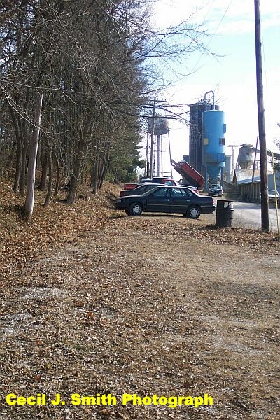
Left:: Part of the old mainline through Paoli, circa 2003. This part of the old right of way was behind what used to be the Cornwell Company, formerly Paolic Industries and the Tomato Products Company. The cars in the picture are parked on the former mainline. The water tower pictured still displays the Cornwell name.
MP D 8.6 7th Subdivision
Left: Railroad south of Paoli. Looking towards French Lick along the former line just outside Paoli. The cinders that once held the ties can still be seen. Right: This, I believe, is Braxton. Looking railroad south along the former right of way.
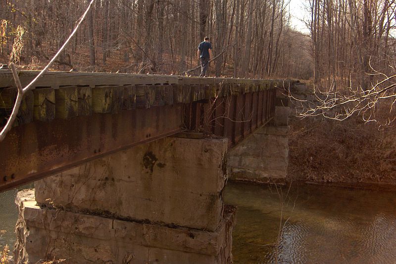
Bridge, south of Paoli on the former French Lick Branch, circa 2009. -Justin Asbery photos-
Left: Not much remains at Braxton. In November of 1979, you are looking down the former right of way toward the south. Right: The Town of Braxton.
M.P. D 11.2 7th Subdivision Glass Rock is another named location along the French Lick Branch.It was first listed on LNA&C Timetable #10. Documents indicate that at one time a proposed track into a local quarry was considered.
Left: Bridge at Glass Rock circa 1983. Right: Another look at the bridge
Looking at the embankment east of the bridge at Glass Rock, January 2007.
Left: Looking at the south exposure of the bridge. Right: The north side of the bridge looking west.
Left and Right. More photos of the bridge D 12.8 at Glass Rock. Edwin Ward photos-
Left: Side view of the bridge looking to the north. Right: Looking East, towards Paoli from the deck. -Edwin Ward photos-
The former Franch Lick Branch right of way passes through the Wilstem Guest Ranch, between Glass Rock and Abydell. Thanks to General Manager Misty Weisensteiner for allowing Justin Asbery access to the old right of way passing through Ranch. Left: Looking west along the old right of way from the road leading back to the office. Today they use the right of way for a horse trail. Right: This photo shows a rock cut that the right of way went through. View is facing west towards French Lick.
Left: This is the view from the end of Wilstem's property. Again, facing towards French Lick. Right: This is the view facing east towards Paoli from the road back to the office.
MP D 13.1 7th Subdivision
Left: Looking down the old ROW at Abbey Del. Right: Old box culvert at Abby Dell -Edwin Ward Pictures-
Left and Right: More views of the stone box culvert on the old ROW. -Edwin Ward Photographs-
The old FL ROW at Abby Del. -Edwin Ward Photographs-
MP D14.2 7th Subdivision Campbell(s) is one of those named places along the railroad. Still searching information on what purpose or business was every located at this location. It was last listed on CIL time table #23. Between Campbell and West Bade there once was a series of bridges. The bridge pictures below are between Campbell and West Baden over Sulphur Creek.
Left: Former French Lick right of way at MP 14.9 Right: Some bridge caps remain. -Pete Pedigo Photos-
Left and Right: Remains of bridge 15.1. -Pete Pedigo Photos-
Left and Right: Close up shots of what remains of bridge 51.1 -Pete Pedigo Photos- Left, Right and Below: Bridge 15.3 over Sulphur Creek, about 2 miles east of West Baden, circa early 1950's.
Left and Right: Bridge 15.3 today. There is still some rail in place. -Pete Pedigo Photos-
|


Return To Home | Contact Us | About Us @2004-2024 Monon Railroad Historical-Technical Society, Inc. All rights reserved.