|
M.P. 207.8 - 4th Subdivision - NE
Bygone Quarry Page Stinesville has been credited with being the location where the Indiana Limestone Industry began. Platted in 1855, Stinesville was named for Eusebius Stein. Stein was a large landowner and started two businesses in town, a grist mill and sawmill. He also assisted in laying out the town. The first post office was established in 1831 at Mount Tabor and later moved to town in 1860. A monument in Victor Oolitic Park commemorates this area as the start of the limestone industry in Indiana. The first quarry opened in 1827 and the first commercial quarry opened in 1855 with the arrival of the railroad. The railroad maintained a quarry branch that has had the usual multiple relocations to the east of the town. The first quarry failed in 1868, but it is still recognized as the start of the industry.
Looking down Main Street, Stinesville 1905.
Stinesville. Left: Downtown Stinesville with corner of the depot pictured. Railroad south is to the right side of the picture. Right: Southbound passenger crosses Jack's Defeat Creek north of the depot.
Stinesville Depot. Left: Northbound passenger stopping at Stinesville, date unknown. Right: Great picture of locals posing at the depot. Again, date unknown.
Left: Stinesville 1940-1950's. F3 on the point of a passenger stopping at Stinesville. Exact date unknown. Right: Bridge over Jack's Defeat Creek north of town, circa 1960's.
Left: Looking north along the mainline at Stinesville, November 1979. Right: Stinesville, looking south along the mainline.
Stinesville 2004
Stinesville 2004. Left: This location is north of Stinesville between the town and the White River bridge. This area was known as Kelly's Cut. Legend has it that an engineer named Kelly took the curve here too fast and he rattled the occupants of the business car on the end of the train. The railroad made a tight curve to the left. Right: Looking at the former mainline north of Stinesville.
The railroad crossed Jack's Defeat Creek twice at Stinesville. Left: The former crossing north of town. Right: The other former bridge site south of the depot location. Ron Marquardt informed me that at one time a stone mill would have been to my left. I'm standing on the old right of way.
Left: Looking north along the former right of way. You are standing in Victor Oolitic Park. Right: Historical marker also in the park.
Stinesville area 2022 Pictures by Nathan
Miles
M.P. 212.2 - 4th Subdivision - NE
Left and Right: Pictures of the clean up of a wreck at Adams. This accident happened September 29, 1960. -Lloyd Kimble Photographs-
Damaged freight cars at Adams. -Lloyd Kimble Photographs-
Left: Big hooks lift a damaged box car at Adams. Right: As cars are moved, new track are brought in. -Lloyd Kimble Photographs-
Left: Mainline is almost all cleared. Right: Main is cleared so a passenger train can get by. -Lloyd Kimble Photographs-
Left and Right: The original Matthews Brothers Mill. This Mill was built before 1874. There is a building that was the Matthews Brothers Store that was built in 1974 and is visible in both images. -Monroe County Library Collection-
Left: Matthews Brothers Stone Company. Note Monon tracks on the right side of the photo. Left: Another look at the main building. This company is now ByBee Stone Company. -Monroe County Library Collection - Matthews Brother employee parking, 1920's. -Monroe County Library Collection-
Left: Another building at Matthews Brothers. Right: Inside the mill building. -Monroe County Libray Collection-
Left and Right: Indside the main mill at Matthews Brothers.
Left: Carvers work at Matthews Brothers, unknown date. Right: Packing stone with excelsior for shipment. -Monroe County Library Collection-
Mathews Brothers Stone Company Employee Photo. -Monroe County Library Collection-
Left and Right: The Matthews Mansion. Home of John Matthews 1806-1883. Founder Matthews Stone Company. Picture on the left is from the early 1900's. No date on the picture to the right. -Monroe County Library Collection-
Left: November 1979. The Matthews Mansion. Built by John Matthews. This house also was the home of the President of the McNeely Stone Company, Inc. What are the odds he was named McNeely. It was build by John Matthews of the Matthews Brothers Stone Company. Right: Backside of the Matthews Mansion. It is said to be haunted, with people reporting hearing voices and strange sightings.
Left: November 1979, Bybee Stone Company. Officially they list Ellettsville as their address. Right: Inside the cutters building, November 1979
Adams, Indiana. Left: Mainline at Adams, looking north. Right: November 1979. Matthews Brothers Stone Store at Adams. This building was erected in 1874, just north of the Mill.
Adams 2004
Left: Right of way north of Adams. This was the location of the north end of Adams siding. Right: Former crossing at Maple Grove Road. The south end of the mainline and siding at Adams. Both views are looking north.
Left Pictured is the former President's home of the old McNeely Stone Company, circa 2004. The home is currently being used a apartments. It is also rumored to be haunted. Right: Front gates of the Bybee Stone Tool Company at Adams. The mainline would be to the right side of the image.
M.P. 213.1 - 4th Subdivision - Z The town was founded in 1837 and later incorporated in 1866. It gets its name from the first merchant to get established, Edward Ellett. Ellettsville's proud heritage is rooted in the limestone industry. "Millions of tons of building stone have been shipped by trains and trucks throughout the United States to build magnificent memorials, cathedrals, government buildings, libraries, public schools, colleges and universities, and countless churches and synagogues. Included in these shipments have been priceless carvings that have told the rich history of our states and national capitol. Craftsmen from our limestone mills have traveled throughout the nation to do on-site work on these structures in building American history" (by Maurice Endwright), hence the town's motto, "Builders of American History." Today, Bybee Stone Company still produces great designs and limestone works at its mill in Ellettsville. The stone for the rebuilding of the Pentagon was provided by Bybee Stone after the September 11, 2001 attacks.
Northbound approaching the depot at Ellettsville. -Robert Wheeler Photograph-
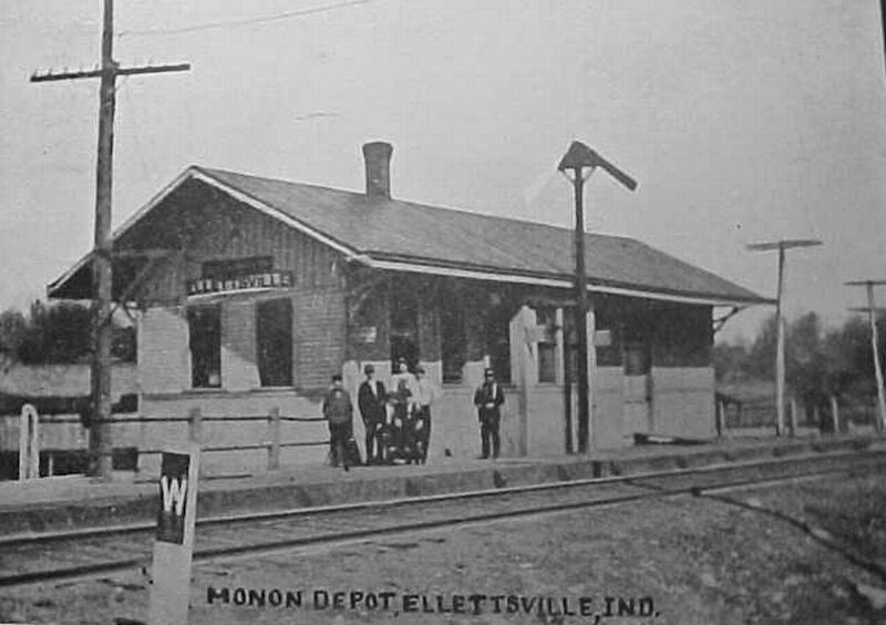
Ellettsville, Indiana depot. Date unknown, however, based on clothing early 1900's might be a good assumption.
More images of the first Ellettsville depot. Thanks to research by Pete Pedigo of Bloomington, Indiana, we know that this original Monon depot was burned in a train wreck that happened on August 11, 1905. This depot was located about 1500 feet north of the last depot location. After the wreck and fire a hotel room and a box car were used as the depot. The newspaper reported that the railroad bought the property on the curve for a new station in October of 1907 and the railroad was going to move the depot to that location, away from the quarry area. -Both images from the Pete Pedigo Collection-
Another shot of the Ellettsville Depot.
The backside of the depot, looking East. Jack's Defeat Creek is in the foreground.-MRHTS Archives Collection-
Left: Ellettsville Indiana depot, date unknown, awaits demolition. Like most small town depots along the line, once they served no purpose, they were unceremoniously torn down. At one time this depot was an essential part of the community. Time worn, it sits abandoned in this picture. Right: Excellent shot of the trackside wall of the depot.
Left: November 1979, Ellettsville, Indiana. Depot shot, looking towards the railroad north. Right: Another view of the depot at Ellettsville, looking south toward Bloomington.
Passing the Ellettsville Depot in fall and winter. Northbound freight.
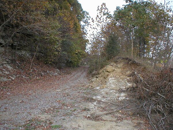
Left: Right of way passing the gas facillity. Right: Looking north along the right of way south of the highway.
Ellettsville 2004
Left: Downtown Ellettsville. Sale Street on a quiet Sunday morning. Right: Site of the depot pictured above. Jack's Defeat Creek is to the left side of the image.
Left: Looking to the north along the former mainline. Pictured taken from sidewalk of the new Route 46. Right: Looking to the south and Bloomington. Tracks still remain, for how long is anyone's guess.
The former Elletsville depot, February 2005. The depot was moved to private property south of Bloomington, where it sits today. Ellettsville area 2019 Pictures by Nathan
Miles
M.P. 215.5 - 4th Subdivision -
Woods 2005. Left: Looking to the RR north at Loesch Road. Rails have recently been removed. Right: Loesch Road looking to the RR south. During July of 2005, the section of former Monon right of way, through this location, became another section of abandoned and removed right of way. Salvage crews worked to remove the rails. Yet another part of the Monon that is gone forever.
Former crossing at Woodyard Road. Left: Looking RR north. Signal mast, pictured above, can be seen in this image too. Right: Looking from the crossing south, towards Bloomington.
M.P. 217.9 - 4th Subdivision -
Left: Northbound freight gets a little push from one of the McDoel switchers. Using motive power on the end of trains was a common practice throughout the Monon diesel era. NW2 #16 applies its 1000 horses to the end of the train at Hunters, IN, circa 1947. Right: L&N consist of mixed motive power, including ex-Monon RS2 260, draws around the curve with a southbound freight at Hunters, IN in August of 1972.
Hunters, Indiana, circa 1979. Left: Looking north along the mainline. Right: The mainline, looking to the south.
Hunters 2004
Hunters Area 2022 Pictures by Nathan
Miles
|


Return To Home | Contact Us | About Us @2004-2024 Monon Railroad Historical-Technical Society, Inc. All rights reserved.