The Ahlgrim Park Case
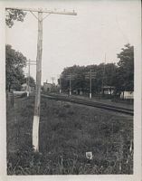
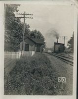
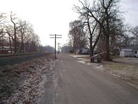
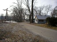
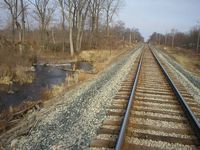
Picture 1 and Picture 2. The pictures here were posted
on my Bygone Places Shelby page. They were also posted to the Monon Railroad
Historical-Technical
Society's Discussion
List. It was my contention that in both these images you are looking south
toward the Knakakee River from a position near Ahlgrim Park, now called Shady
Shores.
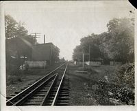
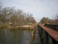
Picture 3. In this image, the contention was that you
were standing on the north end of the Kankakee River trestle looking north
towards
Shelby. Also note Kankakee River sign.
Several people within the Monon Railroad Historical-Technical
Society attempted to correct my conclusions, saying that based on shadows,
the 2003 Tour Book and 1947 Valuation Plans, these buildings were all on
the south
side of the Kankakee River.
Here, I will defend my contention that my original
descriptions were correct. In pictures 1 and 2 above, you are indeed north
of the Kankakee River, looking south towards Thayer, and in picture 3,
you are indeed looking north toward Shelby. The evidence will be overwhelming,
but when I'm finished, there will be no doubt that my original premise
was correct.
 Exhibit
A Passenger Timetables. Note Water Valley is listed as
a stop. The building
pictured to the east of the tracks was at one time a depot. The 1932 Val
Plans show this building and a cinder platform. Look closely at Picture
2 and you can see there is a cinder platform between the structure and
the tracks. This depot, later section house, served the many hunting lodges
and Ahlgrim Park. Check out the 1895
Timetable too. Water Valley is also listed as a station. The building
pictured with the white fence was in all likelihood the former depot for
Water Valley.
Exhibit
A Passenger Timetables. Note Water Valley is listed as
a stop. The building
pictured to the east of the tracks was at one time a depot. The 1932 Val
Plans show this building and a cinder platform. Look closely at Picture
2 and you can see there is a cinder platform between the structure and
the tracks. This depot, later section house, served the many hunting lodges
and Ahlgrim Park. Check out the 1895
Timetable too. Water Valley is also listed as a station. The building
pictured with the white fence was in all likelihood the former depot for
Water Valley.
 Exhibit
B Close up shot of the structure on the east side
of the tracks which at one time was a depot. Note the cinder platform.
Exhibit
B Close up shot of the structure on the east side
of the tracks which at one time was a depot. Note the cinder platform.
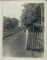
 Exhibit C In this image
you are looking south along the east side of the tracks. This is the approximate
location where Picture
1
was taken. The road crossing had not yet been built, therefore it could not
be in Picture 1, picture 3 or Exhibit B picture.
Exhibit C In this image
you are looking south along the east side of the tracks. This is the approximate
location where Picture
1
was taken. The road crossing had not yet been built, therefore it could not
be in Picture 1, picture 3 or Exhibit B picture.
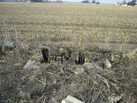
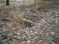 Exhibit
D This chunk of concrete foundation is in
the general vicinity of where the structure is in the pictures
above, on the east side of the tracks.
Exhibit
D This chunk of concrete foundation is in
the general vicinity of where the structure is in the pictures
above, on the east side of the tracks.
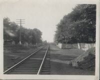 Exhibit
E Looking north along the mainline, circa 1900. Note
once again the cinder platform west of the depot and fence. Also take note
of the houses on the left side of the image.
Exhibit
E Looking north along the mainline, circa 1900. Note
once again the cinder platform west of the depot and fence. Also take note
of the houses on the left side of the image.
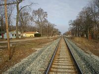 Exhibit
F Circa 2006. You are looking north along
the right of way from approximately the same vantage point as the Picture
3 above. Do the houses look familiar? Note also that the land between the
pole pictured is just slightly lower than the right of way. Also, at the
yellow house pictured the road drop down. Interesting, eh? Almost like
it could have been one of the sidings pictured in the 1900 pictures. Oh
yea, one more feature to note in this picture. In front of the second pole
on the left, note the concrete slab, once a foundation. Could this be where
the pump house sat? On closer inspection, part of the slab has been removed.
It was almost 12 feet across. The 1932 Val Plan shows a pump house. Interesting,
isn't it?
Exhibit
F Circa 2006. You are looking north along
the right of way from approximately the same vantage point as the Picture
3 above. Do the houses look familiar? Note also that the land between the
pole pictured is just slightly lower than the right of way. Also, at the
yellow house pictured the road drop down. Interesting, eh? Almost like
it could have been one of the sidings pictured in the 1900 pictures. Oh
yea, one more feature to note in this picture. In front of the second pole
on the left, note the concrete slab, once a foundation. Could this be where
the pump house sat? On closer inspection, part of the slab has been removed.
It was almost 12 feet across. The 1932 Val Plan shows a pump house. Interesting,
isn't it?
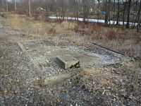 Exhibit
G Close up of the concrete foundation/ slab.
Where the leaves and weeds are in the middle of the slab, it appears that
it had been filled in with dirt. Could at one time this be where the pipes
from the pumps were?
Exhibit
G Close up of the concrete foundation/ slab.
Where the leaves and weeds are in the middle of the slab, it appears that
it had been filled in with dirt. Could at one time this be where the pipes
from the pumps were?
 Exhibit
H Looking
south towards where the pump house once sat. Note how roadway rises like
a grade crossing. The interesting
thing
is
that the road
turns to the left and continues on at the same level. This was the siding
that was pictured in the 1900 pictures that turns off west. Since the pump
house was coal fired, it is speculated that a car load of coal would be spotted
there and unloaded. The concrete foundation is behind the third pole (The
one that is leaning to the right.).
Exhibit
H Looking
south towards where the pump house once sat. Note how roadway rises like
a grade crossing. The interesting
thing
is
that the road
turns to the left and continues on at the same level. This was the siding
that was pictured in the 1900 pictures that turns off west. Since the pump
house was coal fired, it is speculated that a car load of coal would be spotted
there and unloaded. The concrete foundation is behind the third pole (The
one that is leaning to the right.).
 Exhibit
I Looking down the road where the old siding once
went. Near the garage pictured the roadway dips down, indicating the end of
the siding.
Exhibit
I Looking down the road where the old siding once
went. Near the garage pictured the roadway dips down, indicating the end of
the siding.
 Exhibit
J In Picture 3 and Exhibit E above on the west side
of the tracks, in the distance, is pictured a water tank. On the east side
of the tracks the home signal for the crossing is also visible in the
picture. According to the 1932 Val Plan revision, it shows a water tank
which was removed
prior
to
the revision. The water tank was located about 100 yards south of the Monon
- Illinois, Indiana and Iowa crossing in Shelby proper. The home signal is
about 30 yards north of where this water tank was. Pictured are the remains
of that water tank. It is 100 yards south of the crossing,
on the
west side of the tracks. Note the pipe. When looking down the pit, the pipe
ran south alongside the tracks to the pump house pictured in the 1900 pictures.
Exhibit
J In Picture 3 and Exhibit E above on the west side
of the tracks, in the distance, is pictured a water tank. On the east side
of the tracks the home signal for the crossing is also visible in the
picture. According to the 1932 Val Plan revision, it shows a water tank
which was removed
prior
to
the revision. The water tank was located about 100 yards south of the Monon
- Illinois, Indiana and Iowa crossing in Shelby proper. The home signal is
about 30 yards north of where this water tank was. Pictured are the remains
of that water tank. It is 100 yards south of the crossing,
on the
west side of the tracks. Note the pipe. When looking down the pit, the pipe
ran south alongside the tracks to the pump house pictured in the 1900 pictures.
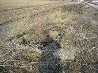
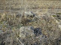
Exhibit K and L Two more
views of the remains of the water tank, south of the crossing. In Exhibit
K, you can see the crossing
in the distance.
 Exhibit
M This photo is the Picture Of The Week.
Monon K-2 Pacific #412 northbound at Shelby. This picture therefore had
to have been
taken from the water tank that once stood south of the Monon - 3I crossing
at Shelby. How do I know that? If you have never been to Shelby, there
are no structures between the crossing and the river where this picture
could have been taken. No elevator, barn or buildings on the west side
of the tracks. It is all farm fields. It would be unlikely it was taken
from an aircraft. Water Valley is in the
distance.
Note
the
building
on the
east
side of
the
tracks.
Look
familiar?
How
about
the
building
on
the
west side of the tracks?
Exhibit
M This photo is the Picture Of The Week.
Monon K-2 Pacific #412 northbound at Shelby. This picture therefore had
to have been
taken from the water tank that once stood south of the Monon - 3I crossing
at Shelby. How do I know that? If you have never been to Shelby, there
are no structures between the crossing and the river where this picture
could have been taken. No elevator, barn or buildings on the west side
of the tracks. It is all farm fields. It would be unlikely it was taken
from an aircraft. Water Valley is in the
distance.
Note
the
building
on the
east
side of
the
tracks.
Look
familiar?
How
about
the
building
on
the
west side of the tracks?
February 17 2006 Rebuttal
I have spoke of the 1932 Revision of the Val Plan.
Well, now it is time to present the clincher:
Exhibit 1 Shelby PDF
File
Rebuttal Exhibit
1 1932 Revision
of the 1915 Valuation Plan. True north
is clearly marked on the plan. The right of way follows a northwest path
through the area. Note the footprint of a structure on the east side
of the tracks. That is
the
depot like building pictured. Note the notation of the cinder platform. The
structure in the pictures has said cinder platform. Note the siding going
of to the
east north of the building. It is marked retired, so it was removed by the
1932 revision. Same siding as in the photos above. Now, look on the west
side of the tracks. Note
the
footprint
for
the
Pump
House
and
Coal Bin.
Oh, one more thing, note the Kankakee River sign, in picture 3 above, is
noted on the plan. The second siding, going off to the southwest
is not shown,
but
it is
possible
that it was added or taken out before this revision was completed. I contend
that it was used to deliver coal to fill the coal bin. Here are some mile posts
from the Val Plan: The numbers in parentheses are those omitted from
the full number by convention from the notes on the plan.
Ends of Cinder Platform between side track and bridge (28)11+00=53.23 to
(28)16+00=53.33
Pump house (28)12+40 =53.26
Coal Bin (2812)+57 =53.27
Kankakee River Sign (28)13+11 =53.27
End of Pile trestle Br 53.3 2814+06 =52.29
County Line 2816+50 =53.34
Note that the MP's are increasing toward the river
indicating a southward direction and placing the stuff on the north side
of the river.
It was stated that because there was a water
tank south of the river, as verified by the 1947 Val Plan and Tour Book,
why have two water tanks that close? I don't have the answer to that question.
Look just railroad south, actual direction southest of the Monon
-
3 I
crossing.
Please note the notation for the center line of a water tank that was
retired. This location corresponds to the foundation supports and the pipe
that I found 100 yards, give or take, south of the crossing on the west
side of the tracks, Exhibits J, K and L. So, yes, at one time there was
a water tank north of the river and odds are the pump house in the pictures
pumped
water
north
to this tank. Also note the home signal, railroad south, again southest of
the tank. In the photos, the home signal
is visible, although blurred on
the east
side
of
the tracks, right side of photograph,
southest of the water tank.
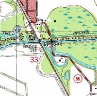
Rebuttal Exhibit 2 This
topographical map was used in an attempt to verify that the buildings pictured
about had
to have been south of the
river.
The criticism is: "Tom claims that on his Exhibit N (the valplan
with the name "Water Valley across its top), "north is to the
left".
It is not. It is to the right." The image above is a larger section
of the Terraserver map. "I've
attached it and a portion of the topo of the same place (just a single
tile because
I have
no idea how to attach
the whole thing).
On both Exhibit B and the topo tile, look at the shape of the river and
its sloughs or bayous or whatever you want to call them (I call them sloughs).
Now, on the topo tile, look at the mouth of the slough just east of the
MONON bridge where the "B" in "BM 644" is. Compare
this to the river bank patterns in Tom's Exhibit B. On it, the mouth of
the adjacent slough is BELOW the bridge, meaning that east is down on Exhibit
B and therefore, north is to the right, not the left. Plus, look at the
way the slough gradually gets further from the track the further to the
left on Exhibit B you look. It does on the topo, too, but that direction
clearly is SOUTH."
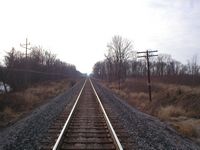 Rebuttal
Exhibit 3 This
picture was taken from the south bank of the Kankakee River, looking to
the southeast along the mainline. Using
the
topo map
above, it was taken left of the "B" in the BM 644. Do you see
a slough
or channel running alongside the tracks? To the left side of the
image, there is a channel, slough or bayou pictured. This channel starts
south of the river, for about 50 yards, then turns to the left and ends
at a service road that was built when the new highway bridge was constructed.
According to the topo map, the slough, or bayou continues south along the
railroad right of way. Looking down the tracks, do you see any water past
the first pole pictured? When I walked the location and took this picture,
I could not see any either.
Rebuttal
Exhibit 3 This
picture was taken from the south bank of the Kankakee River, looking to
the southeast along the mainline. Using
the
topo map
above, it was taken left of the "B" in the BM 644. Do you see
a slough
or channel running alongside the tracks? To the left side of the
image, there is a channel, slough or bayou pictured. This channel starts
south of the river, for about 50 yards, then turns to the left and ends
at a service road that was built when the new highway bridge was constructed.
According to the topo map, the slough, or bayou continues south along the
railroad right of way. Looking down the tracks, do you see any water past
the first pole pictured? When I walked the location and took this picture,
I could not see any either.
 Rebuttal
Exhibit 4 This
picture was taken from the service road, looking west. Remember the right
of way runs from the southeast to the
northwest.
This location on the topo map is near the small black square under the "M" in
the BM 644. You can also see the Monon bridge, Kankakee River and the mouth
of the slough or bayou.
Rebuttal
Exhibit 4 This
picture was taken from the service road, looking west. Remember the right
of way runs from the southeast to the
northwest.
This location on the topo map is near the small black square under the "M" in
the BM 644. You can also see the Monon bridge, Kankakee River and the mouth
of the slough or bayou.
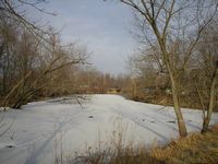
 Rebuttal
Exhibit 5 This picture was taken from the center
of the Monon bridge across the Kankakee River. You are looking northwest.
The
white
beyond the poles pictured is ice on the bayou. This inlet, or bayou is
indicated on the topo map. When compared to the Val Plan in the PDF file
above, they match, except that the Val Plan shows the bayou longer. What
is known as Shady Shores today contains several bayous and channels. In
the older pictures above there is a siding going south (Remember the right
of way between Shelby and Thayer runs from the northwest to the southeast.) I
contend that when this siding was built, that channel was in all likelyhood
filled in, which is why it was shown longer on the original 1915 Val Plan.
When the plan was drawn in 1915, I suspect the bayou did meander around
inside Ahlgrim Park. In 2006 there are several bayous winding through the
area. Also, note all the houses pictured. These are indicated on the topo
map as black dots. The houses pictured above look like they match up with
all the dots. Look at Exhibit P again. Do you see any houses south of the
river. In pictures 1, 2 and 3 above there are structures on either side
of the railroad. Where would they be if these structures were south of
the river, as it is suggested and supported by the topo map. Maybe they
were all taken out, or maybe because there were no houses south of the
river except for the Folgi Hotel, indicated on the topo map by the two
black dots under the "44" in the BM 644. The other buildings
in 1, 2 and 3 above are closer to the pump house and the building that
looks like a
depot. From the right of way, I estimate the Folgi Hotel is at least 200-250
yards from the right of way.
Rebuttal
Exhibit 5 This picture was taken from the center
of the Monon bridge across the Kankakee River. You are looking northwest.
The
white
beyond the poles pictured is ice on the bayou. This inlet, or bayou is
indicated on the topo map. When compared to the Val Plan in the PDF file
above, they match, except that the Val Plan shows the bayou longer. What
is known as Shady Shores today contains several bayous and channels. In
the older pictures above there is a siding going south (Remember the right
of way between Shelby and Thayer runs from the northwest to the southeast.) I
contend that when this siding was built, that channel was in all likelyhood
filled in, which is why it was shown longer on the original 1915 Val Plan.
When the plan was drawn in 1915, I suspect the bayou did meander around
inside Ahlgrim Park. In 2006 there are several bayous winding through the
area. Also, note all the houses pictured. These are indicated on the topo
map as black dots. The houses pictured above look like they match up with
all the dots. Look at Exhibit P again. Do you see any houses south of the
river. In pictures 1, 2 and 3 above there are structures on either side
of the railroad. Where would they be if these structures were south of
the river, as it is suggested and supported by the topo map. Maybe they
were all taken out, or maybe because there were no houses south of the
river except for the Folgi Hotel, indicated on the topo map by the two
black dots under the "44" in the BM 644. The other buildings
in 1, 2 and 3 above are closer to the pump house and the building that
looks like a
depot. From the right of way, I estimate the Folgi Hotel is at least 200-250
yards from the right of way.
 Rebuttal
Exhibit 6 In this image you are looking to the northest
along the right of way. In the distance you can see the Kankakee River
bridge. On the topo map this location would be left of the black dot I
have already identified as the old Folgi Hotel. According to the topo map
there should be a slough or bayou to the right side of the image. Do you
see any? I sure did not. The culverts pictures on the left are all that
remain of Bridge 53.5. Unfortunately I did not take pictures of the east
side of the tracks and the culverts on that side.
Rebuttal
Exhibit 6 In this image you are looking to the northest
along the right of way. In the distance you can see the Kankakee River
bridge. On the topo map this location would be left of the black dot I
have already identified as the old Folgi Hotel. According to the topo map
there should be a slough or bayou to the right side of the image. Do you
see any? I sure did not. The culverts pictures on the left are all that
remain of Bridge 53.5. Unfortunately I did not take pictures of the east
side of the tracks and the culverts on that side.
March 06, 2006 Some
New Evidence
March 4, 2006. While at the Monon Railroad Historical-Technical
Society Inc. World Headquarters in Linden, Indiana researching another
project, several drawings were brought to my attention by Robert Wheeler,
Chief Archivist for the MRHTS Inc. The Archives at Linden contained several
maps and drawings of Water Valley and the location being debated. I will
attempt to post as many as I can once they are converted into PDF file
format. Since the Society has no copier with the capacity to copy these
drawings full size they were done in sections by Warren Mitchell and Robert
Wheeler.
Monon Railroad Drawing, 7-2-1941
This drawing, dated July 2, 1941 drawn by the Office
Of Engineering Maintenance Of Way, shows the proposed location of a tank
in Water Valley. Note some familiar features. The depot, which is marked
Station House, the Pump House and Coal Bin and of course the Kankakee River
sign. On earlier drawings Bob found the inlet marked "Back Water" was
listed as a Coal Barge slip. I hope to have this drawing posted in the
near future.
Retired
Track I.C.C. 31 This is a drawing of retired track at Water Valley,
by the Office
Of Engineering Maintenance Of Way, June 10, 1925. This was also found in
the Archives, in the Water Valley folder. This is the siding leading off
to the left, near the station, in some pictures above. This siding was
taken out in 1925.
Back


