9th Subdivision - Chicago And Wabash Valley
The Chicago and Wabash Valley Railroad Tour, 2003
The Monon Historical-Technical Society's 2003 Convention is history. Those who attended the convention and participated in the bus tour of the Chicago and Wabash Valley, I hoped enjoyed the tour. Welcome to my virtual tour of the line. In the coming days I will be adding more pictures and additional information about the Chicago and Wabash Valley. I would like to acknowledge the work of Mr. Robert Wheeler of the Monon Railroad Historical Technical Society for his work on the track diagrams and also the Monon Railroad Historical Technical Society for allowing me use of them here.
We begin our tour at the northern end of the line. Dinwiddie Station was "officially" the farthest north Gifford's railroad operated. The the line was surveyed to the PCC&StL, the crossing exists only on the original plans. Tracks were extended a few miles north of State Road 2 and was actually graded to just south of 153rd. Here is our first stop.
End Of The Line (North)
View Track Schematic
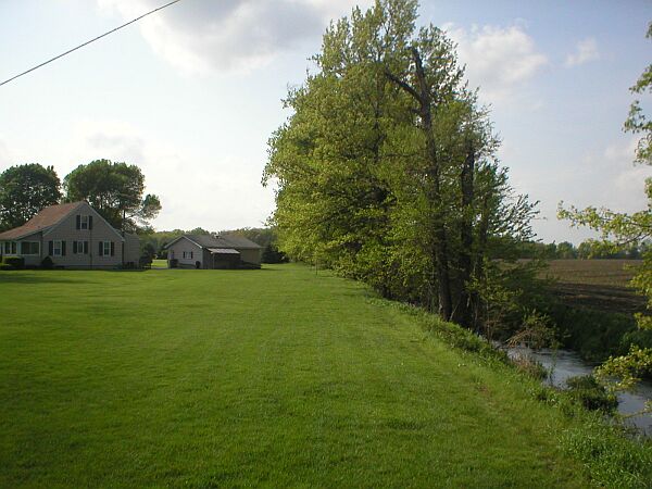
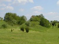 The
northern most part of the C&WV. The end of the track, north of Dinwiddie.
This picture was taken from 153rd Avenue and Harrison Street. According to
official records, the grading and track ended here. The line was surveyed to
a point north of the old Pennsylvania line at State Road 231 and Route 53 (Broadway)
near Crown Point. The line split at
153rd Avenue, at a spot that was to be named Gifford's Switch. The west line
was to proceed into Crown Point and interchange with the PCC&St.L there, using
their depot/terminal facilities. The east line was to proceed north to Gary,
Indiana, with an overcrossing of the Panhandle and Erie, plus an interchange
with the Erie. This was relayed to John Eagan, who sent some pictures below,
by Ray Buttron, of Crown Point. Mr Buttron has a barn dating from 1895 and
his great uncle worked on the line. Quite an undertaking had they accomplished
the feat!
The
northern most part of the C&WV. The end of the track, north of Dinwiddie.
This picture was taken from 153rd Avenue and Harrison Street. According to
official records, the grading and track ended here. The line was surveyed to
a point north of the old Pennsylvania line at State Road 231 and Route 53 (Broadway)
near Crown Point. The line split at
153rd Avenue, at a spot that was to be named Gifford's Switch. The west line
was to proceed into Crown Point and interchange with the PCC&St.L there, using
their depot/terminal facilities. The east line was to proceed north to Gary,
Indiana, with an overcrossing of the Panhandle and Erie, plus an interchange
with the Erie. This was relayed to John Eagan, who sent some pictures below,
by Ray Buttron, of Crown Point. Mr Buttron has a barn dating from 1895 and
his great uncle worked on the line. Quite an undertaking had they accomplished
the feat!

MP K 32.0 9th Subdivision -
View Track Schematic


Dinwiddie Station. The name come from the family of J.D. Dinwiddie. Construction reached here in 1906. This area, and the Lowell Grain Company, were once served by the Chicago and Wabash Valley. The tracks ended north of this location and there were two seperate tracks, although they were never used. Left: This picture was taken from State Road 2, about half a mile west of I-65, looking southeast. Today the area is thriving with the nearby I-64 interchange. Right: Close up view of the old right of way. This picture was taken from the driveway that is pictured in the image above. You are looking toward the southeast.
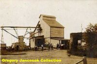 The Dinwiddie Supply
Company and Elevator. This business was the second elevator on the end of
the Chicago And Wabash Valley Railroad. Although not positive, this business
would be where the Apple Valley Mobile
Home Park is today.
The Dinwiddie Supply
Company and Elevator. This business was the second elevator on the end of
the Chicago And Wabash Valley Railroad. Although not positive, this business
would be where the Apple Valley Mobile
Home Park is today.

MP K 30.1 9th Subdivision -
View Track Schematic
The name Range Line comes from the location of the town on the dividing line between Ranges 7 and 8 west of the Second Principal Meridian, which is the "survey center" of the State of Indiana. Besides the elevator, there was once a stock pen with chute located here.

The former Fifield Elevator. This image is from 1978, before the lower part of the structure was converted into a private residence. L Coe photograph, courtesy of Skip Breyfogle.
 Range Line Road, south of State Road 2. Fifield Elevator, 2003. The elevator has been turned into a private residence. The mainline once traveled to the north side of the elevator. Countless times I have passed by this location, over the years, and never bothered to stop and look up. The former elevator towers over the surrounding trees. The residence is visable from Range Line Road, south of Route 2, east of Lowell. (Gregory Jancosek photo.)
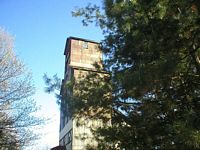

Left: When I did "look up", this is what I saw. I grew up in Lowell. Spent many a day and night driving Range Line Road and never realized this former elevator was there. Right: July 4, 2003. On my way home from the Grand Kankakee County Park I stopped by the former elevator. This time I found the owners home and they allowed me to take this photo. You are looking back to the northwest along the former mainline. The homeowner stated that they have had many people over the years taking pictures.
 Looking
to the northwest from Singleton Ditch. This picture was taken southeast of
the elevator at Range Line. April
18, 2004 John Eagan visited the area and spoke with the owner of the property,
Warren, who said that the driveway is actually on the "house" track, the mainline
is now a drainage ditch that he plans to bridge with some sort of patio. If
you look closly to the pictures, you can still see bridge pilings in the ditch.
Looking
to the northwest from Singleton Ditch. This picture was taken southeast of
the elevator at Range Line. April
18, 2004 John Eagan visited the area and spoke with the owner of the property,
Warren, who said that the driveway is actually on the "house" track, the mainline
is now a drainage ditch that he plans to bridge with some sort of patio. If
you look closly to the pictures, you can still see bridge pilings in the ditch.
 Another view of Singelton Ditch and the old bridge pilings.

MP K 27.1 9th Subdivision -
View Track Schematic
 From
the Fifield Elevator, the line continued in a southeasterly direction. This
area was shown on timetables as Beech Ridge, which also showed the location
of the switch. The switch was built to service a swamill and ice house, built by Gifford. The sawmill cut lumber for the railroad line and the sawdust was used for the ice. 197th Avenue was the only eastbound road off of Range Line.
Before the road meets Stone Road, it crosses a drainage ditch. After attempting
to walk back to the river, on my way back to Range Line, I stopped to talk
with a farmer. He pointed these pilings out and claim they are from the original
C&WV bridge that crossed the ditch. They look pretty old. This spot is about
100 yards from where the picture below was taken
From
the Fifield Elevator, the line continued in a southeasterly direction. This
area was shown on timetables as Beech Ridge, which also showed the location
of the switch. The switch was built to service a swamill and ice house, built by Gifford. The sawmill cut lumber for the railroad line and the sawdust was used for the ice. 197th Avenue was the only eastbound road off of Range Line.
Before the road meets Stone Road, it crosses a drainage ditch. After attempting
to walk back to the river, on my way back to Range Line, I stopped to talk
with a farmer. He pointed these pilings out and claim they are from the original
C&WV bridge that crossed the ditch. They look pretty old. This spot is about
100 yards from where the picture below was taken

Pilings for an old bridge across drainage ditch. 1978. Lewis Cole photograph.
 This location is the approximate location, or general vicinity of Beech Ridge. The old right of way continued southeast. This photo was shot from Stone Road, east of Range Line Road and off 197th Avenue. When you walk down it, it does have that old roadbed look to it. About one and a half miles along this old right of way is the old brisge site. The farmer who I spoke with said that at one time some old boxcars once sat back by the river, abandoned. When the Lake County Parks Department aquired the land, they removed them. The farmer also claims the old wooden pilings remain at the old Kankakee River bridge location.


Left: This is about how far down the old right of way I walked my first visit. Well, I could see the gate. Right: Almost there. This wire gate is about half way between the first gate and the river.


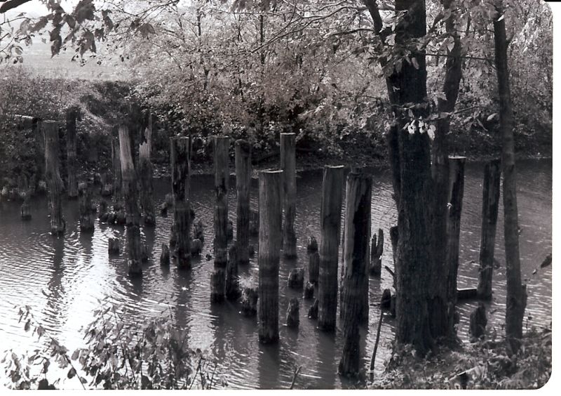
Left: After some dry weather, my mission to photograph the former Kankakee River bridge site was accomplished. Thanks to Robert Studebaker and the Lake County Parks Department for escorting me back to the site. Pictured is the Lake County side of the crossing. Pilings are clearly visible in the river. Right: More pilings, which are close to, or over 100 years old. These are close to the Lake County bank. According to Monon Society records, the bridge had 12 spans. Bob Little, a local farmer, told me that it was rumored that with the exception of the engineer, all other train personel would walk across the bridge.
 The opposite bank. According to Bob Little, who's family has farmed the land for several generations, the rocks visible are what is left of the abutments. He stated that he personally does not remember bridge abutments on either side, just rocks. Mid channel there would be more pilings if the river was really low.
This image is large and may take a few minutes to load. Courtsey of Robert Wheeler, Archivist, Monon Railroad Historical Technical Society.

MP K 25.4 9th Subdivision -
View Track Schematic
This location is between the Kankakee River and DeMotte. Southeast of the Kankakee River the C&WV crossed another major drainage ditch which formed a sort of island. I am not exactly sure if that was the origins of the name. The inventory at one time showed an earth and timbers platform. Original plans had two locations named "Grape Island".


Left: North of Demotte. This picture is of the ROW looking northwest from State Road 231. The line continued northwest and crossed the Kankakee River. Right: Former Route 231 crossing, looking southeast towards Kersey.


Left: County Road 1350N. Looking towards the northwest from 1350N. This location is northwest of Kersey and almost in the Demotte town limits. Right: Same location looking back southeast towards Kersey. ROW was on the west side of the ditch.
| Bygone Monon Main |
Ninth Subdivision |


