|
Quarry Districts Along The MONON Indiana Limestone Lines Indiana has out-produced all of the other states in limestone production. The major areas are in south-central part of the state. The Indiana limestone belt encompasses a large part of Monroe and Lawrence counties, and the limestone belt extends 23 miles from Bloomington to Bedford in central Indiana. Indiana limestone has been quarried since 1880 and "has probably been used more widely than any stone in the world." Indiana limestone is know by several names: Indiana Limestone, Indiana Oolitic Limestone, Bedford Oolitic Limestone, and Bedford Rock. The stone is a buff, gray, and variegated colors. History of Limestone Over 300 million years ago, an inland sea covered most of the Midwest. This sea teemed with billions of microscopic creatures, shell fish, and other denizens of the deep. When they died their calcium-rich carcasses settled into the mud at the bottom. After a while, (say 40-60 million years or so later) the sea dried up, the mud and sea creatures fossilized. Eventually (that would be another 40-50 million years) the mud and sea creatures were covered over by the earth. During the recent ice age (in geological terms the last ice age is recent) huge glaciers slid south over Southwestern Indiana exposing a small area of ancient bedrock between Bloomington and Bedford, Indiana. For more information on the Indiana Limestone and Quarry Districts, visit, Stone Quarries And Beyond . This web site has great information on many of the operations in the State Of Indiana. Peggy and George Perrazzo have put together a nice reference point. They have graciously allowed me to use much of the personal collection on this page, to which I say, "Thank You." Disclaimer, Please Take Note: This
is in no way a complete accounting of the quarries and their operations
in and around
the MONON Railroad or the communities it served. I am no expert in the
field of limestone and quarries. This is meerly a look at some of the
companies that once, and in many instances, still are doing buiness.
I will do my best to make certain that the information is accurate,
based on the information or research I have at my disposal.
Stinesville Area
Adams Area
Left and Right: The original Matthews Brothers Mill. This Mill was built before 1874. There is a building that was the Matthews Brothers Store that was built in 1974 and is visible in both images. -Monroe County Library Collection-
Left: Matthews Brothers Stone Company. Note MONON tracks on the right side of the photo.
Matthews Brother employee parking, 1920's. -Monroe County Library Collection-
Left: Another building at Matthews Brothers.
Left and Right: Indside the main mill at Matthews Brothers.
Left: Carvers work at Matthews Brothers, unknown date.
Mathews Brothers Stone Company Employee Photo. -Monroe County Library Collection-
Left and Right: The Matthews Mansion. Home of John Matthews 1806-1883. Founder Matthews Stone Company. Picture on the left is from the early 1900's. No date on the picture to the right. -Monroe County Library Collection-
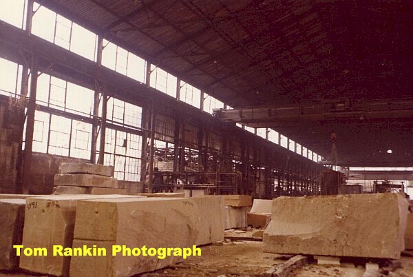
McNeely Stone Company, Inc, Circa 1979.
Left: November 1979. The Matthews Mansion. Built by John Matthews. This house also was the home of the President of the McNeely Stone Company, Inc. What are the odds he was named McNeely. It was build by John Matthews of the Matthews Brothers Stone Company.
The ByBee Stone Company, 1979.
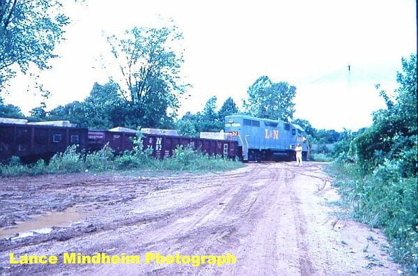
Bloomington Area Hunters Area The shots below are at Reed Quarries, taken by Lance Mindheim. This quarry was served by the branch splitting off the mainline at Hunters. These pictures were all taken July of 1976 after the L&N/SCL/Family Lines takeover.
Maple Hill Quarry
Maple Hill Quarry, 1920's. This quarry is now under the name of C&H Stone, located southwest of Bloomington on Rockport Road. The quarry was at the end of a railroad spur that started in the Clear Creek depot area.
Independent Stone Company & Railroad
Independent
Limestone Quarry, Bloomington, Indiana. Circa 1984.
Left: Another Independent Stone Company
quarry, circa 1977. Looks as if this one has been played out.
Left: Ex-MONON wood caboose that once
served as the yard office at the Independent Stone Quarry. Indian Hill Stone Company
The Indian Hill Stone Company. Left and Right: To looks at the old Indian Hill Company, circa 1977. Sanders Rooftop Quarry is one of the water-filled quarries around Bloomington made famous in the 1979 movie Breaking Away. The quarries enjoy a unique history in the surrounding area. Each one has a story to tell, and "Rooftop" Quarry is one of the most popular. Rooftop Quarry was originally named “Sanders Quarry”. It was also known as "Longhole" and is now owned by Indiana Limestone Company, but there is no active quarry activity presently.
Left: Rooftop, formerly Sanders Quarry. Right: Movie still from Breaking Away at Rooftop.
Above and Below: The Rooftop Quarry, also known to people as "Longhole" is a popular site for cliff diving. This is a highly dangerous sport and the old quarry is on private property. As late as 2008 a person lost his life jumping.
Oolitic Area
Oolitic Quarries. Part of the Bedford
Stone Quarries Company, Inc. Murdock Area
Left and Right: Old quarries on the former Murdock Branch line. Long since shut down and silent, circa 1984.
1923 aerial view of the PM&B Quarry showing the multi-Kiln Lime plant. It is located in the
Left: The south side of the PM&B kilns with the camera facing North West towards the Empire Quarry hole. This must have been on a day when the kilns were not in operation as there is no smoke to obscure the area. The track in the bottom left is the main track into the PM&B quarry.
Left: Lime Kiln at Oolitic/Murdock in the PM&B Quarry. This is all that is left of the Lime operation there. Murdock Branch Line The MONON spur from the Murdock accessed the quarry areas around Bedford. The branch came in from the east instead of the southeast. The images, all from 1984, show the branch line. I am relatively certain that they may be out of sequence, from the start to the end of the branch, however, since they were really not identified with better locations, I did the best I could.
Left: Looking towards the north where the branch leaves
the main towards Thornton.
Left: Looking south towards Furst-Kerber Mill # 2.
Note boxcars sitting on spur.
Left: Along the branch looking towards the north. Nice
fall colors.
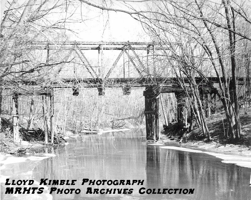
Below: Former MONON Murdock branch looking south towards an old quarry.
Bridge of Salt Creek on the Murdock Branch. This is the same bridge above. No date listed, however Steve Stafford visited the area recently and spoke with several local residents. They identified these pictures as the bridge. I have added several photos of this bridge, circa 2006 on the Murdock Branchline page.
Bedford Area Dark Hollow
Left, Middle and Right: Limestone columns loaded on flatcars at Dark Hollow, May of 1922. The columns were made in 1921 and 1922 by the Doyle Stone Company and the Indiana Cut Stone Company Mill. Doyle owned both companies. By the time the building was finished in 1928, Indiana Limestone owned Doyle Stone and Indiana Cut Stone. Indiana Limestone took credit for this work in their advertising. The columns are heading to Pennsylvania for the North Office Building, Pennsylvania State Capital Group. There were 36 columns in total. There are 15 buildings in the Capitol Group. -Pete Pedigo Collection-
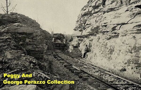
Left And Right: Empire Quarry, Indiana Limestone Company Inc. These pictures are from 2001, from which the stone was taken for the Empire State Building in New York City. Hoosier Quarry 1 & 2 Owned by the Bedford Stone Quarries Company, Inc. The quarries of the Company, consisting of "Hoosier 1 and 2," "Oolitic 1 and 2," "Louisville and Bedford," and "Buff Ridge," are situated about five miles northwest of Bedford, in what is geographically known as "Buff Ridge," a district about one mile wide and about three miles long.
Above: D Quarry picture Hoosier Cut
Stone Company, Bedord, Indiana.
Bedford Belt Railroad Access to the Bedford Stone Quarries was handled through the Bedford Belt Railway, a line owned by the Bedford Stone Quarries Company, Inc. It was about twelve miles in length, and connected with all railroads entering Bedford. The Bedford Belt Railway at one time had three large "Mogul" engines for hauling freight to Bedford from the Quarries, and two smaller engines to do the necessary switching and operate a passenger line between Bedford, Limestone and the Quarries. The completion of the Bedford Belt Railway, connecting all of the Quarries at Bedford with all of the railroads entering there, together with present facilities for obtaining a sufficient number of cars at all times to transport the output, enabled the Bedford Stone Quarries Company to take contracts of any magnitude and to insure prompt delivery. Here is some additional information, courtesy of Tim
Swan, MONON Railroad Historical-Technical Society Members, who has done
comsiderable
research into this region. "About the Bedford Belt Railroad,
according to The Milwaukee Railroader, the Milwaukee Road Historical Society's
magazine,
the Bedford Belt was taken over by the South Indiana Railway (SIRy)
in 1898.
SIRy
was ireorganized
as the Chicago, Terre Haute, and Southeastern (CTSE) in 1910 and was in turn
absorbed by the MILW in 1921. Everybody in this area continued calling
the Oolitic line the Bedford Belt. To access Oolitic, the Belt crossed over
the MONON mainline on a small wood trestle between mileposts 244 and 245.
The MONON spur from the Murdock wye accessed essentially the same area but
from the
east instead of the southeast. I've never seen any evidence that the Belt
connected with the MONON at Oolitic. Since both line's had a myriad
of quarry spurs they must have been very close together in many places. In
the 1890-1920 period, SIRy and the MONON were bitter rivals, each allied
with competing
stone cartels."
Bedford Belt Railroad. The railroad that moved countless
tons of stone in, around and out of the quarries around Bedford, Indiana.
MONON Quarry Pictures
J. F. Bennett photographed the MONON
extensively. Adams Area
McNeely Stone Company, Inc, Circa 1979.
Left: The ByBee
Stone Company, 1979. Left: ByBee Stone Company buildings. The main office
was the building to the
left side of the picture.
The shots below are at Reed Quarries, taken by Lance Mindheim. This quarry was served by the branch splitting off the mainline at Hunters. These pictures were all taken July of 1976 after the L&N/SCL/Family Lines takeover.
|


Return To Home | Contact Us | About Us @2004-2024 Monon Railroad Historical-Technical Society, Inc. All rights reserved.