Mines Along The MONON
Welcome to our newest addition to the Bygone Places Along The
MONON website. This site is still under construction, so be sure to check
back often. Updates will be posted on the index page.
From the beginning, the predecessor lines that eventually
would become the MONON Railroad eyed the coal fields of Indiana. The MONON's
initial entry into these coal fields came via leased trackage. September
1902 the CIL signed an agreement with the Indianapolis Southern for trackage
rights on ten miles of line from Switz City through Linton to the mining
area of Victoria. In combination with the Bedford and Bloomfield Branch,
the rights gave the railroad access to mines in Sullivan and Green counties.
In 1899 the seeds of what was to become the MONON's
third and best route into the coal fields were planted when officers of
the CI&L participated in the creation of the Indianapolis & Louisville
Railway Company. The original I&L charter provided for building a 100
mile line from Indianapolis to Switz City. The line would traverse through
Marion, Hendricks, Morgan, Putnam, Owen, Clay, Sullivan and Green counties.
Early in 1903, real progress was made on the I&L. The line had been
surveyed from the MONON mainline south of Cloverdale to Victoria.

Example of coal mining in Greene County.
In 1905 the final form of the I&L branch was agreed
upon by the MONON's board. The line was to start on the mainline between
Cloverdale and Quincy, at a site named Wallace Junction, after CI&L
Engineer W.A. Wallace. It would extend only to Victoria. To assure that
the CI&L had control of the I&L, the MONON took a 99 year lease
on the I&L, effective January 1, 1906.
The I&L was turned over to the CI&L officially
on October 1, 1907, with the Vicksburg Spur opening later that December.
The I&L counted 59.7 route miles with yet another 10.2 in sidings and
mine trackage. In 1911 the MONON Coal Company, owned by the railroad, was
established to establish a presence in the coal fields. The Lattas Creek
spur provided the MONON with a link to the Chicago, Terre Haute and Southeastern
(later Milwaukee Road) at Lattas Junction.
Excepts From "MONON, The
Hoosier Line" by Gary and Steve Dolzall
CIL Coal Field Lines 1936 PDF
MONON Coal Field Lines - undated- PDF
Peabody Coal Company
The MONON as well as the Milwaukee
Road served the Peabody Coal Company. The MONON reached the tipple via
a spur line that started at the wye a few miles north of Midland. The
Milwaukee Road from the other direction near the Latta yard. Coal was
a major source of revenue on the MONON.
 Midland
Turn, Peabody spur line, long range view, circa 1971.
Midland
Turn, Peabody spur line, long range view, circa 1971.


Left
and Right: Two more images from the Midland Turn and the Peabody spur.
Again, circa July 1971. These
images were taken from the Monon Railroad Historical -Technical Society's
Ron Marquardt Image CD.


Left: Pushing empties at the
Peabody tipple, May 1971.
Right: Peabody Coal Company cars at the tipple,
May 1971.
Victoria
 The S&A Coal Corporation's new coal washer and tipple, circa 1955. Completion
of this
The S&A Coal Corporation's new coal washer and tipple, circa 1955. Completion
of this
structure, in 1954, gave the railroad renewed hope for revenue
on the I&L Branch. Pictured
are MONON hoppers ready for loading. The
structure would be fed by coal from area
strip mines.
 Another
look at the coal washer and tipple at Victoria. CIL hopper #40180 and others
wait to be filled.
Another
look at the coal washer and tipple at Victoria. CIL hopper #40180 and others
wait to be filled.
MONON #2 Hocking Mine
 This
mine is also known as Vandalia #2 was began by The Indiana Southern Coal
Co. about 1905.
This
mine is also known as Vandalia #2 was began by The Indiana Southern Coal
Co. about 1905.
It than became Alliance Coal Co. It Became
MONON Coal
Co.
in
1909...Than
it sold to the
Vandalia Coal Co. in 1911. It was abandoned in 1919. It yielded
891,300 tons. It was located south
and east of Farmersburg, Indiana and about
3.5 miles north of state road 48. Interestingly enough
this area is now being
strip mined by Black Beauty Coal Company.
Vivian-Colliers Twin Mine

Vivian-Colliers Twin Mine near Jasonville.
Queen Coal and Mining Company, Queen Mine

Queen Mine Tipple. The mine was located southweast of Jasonville in Greene County.
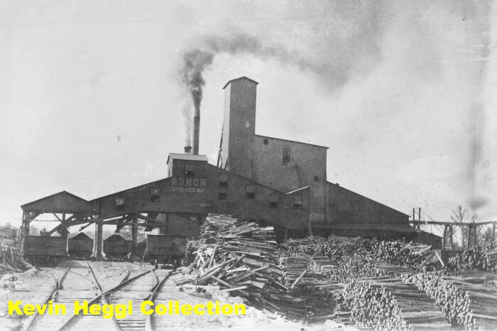
Latta's Creek No 1, MONON #6.
 Latta's Creek No 1, MONON #6. The company names are listed
as: Lattas Creek Coal Co., South Indiana Coal Co.,MONON Coal Co., Alliance
Coal Co. It operated from 1903 to 1923 and dug 3,559.000 tons. It was located
just south of Shakamak State Park, in Green County.
Latta's Creek No 1, MONON #6. The company names are listed
as: Lattas Creek Coal Co., South Indiana Coal Co.,MONON Coal Co., Alliance
Coal Co. It operated from 1903 to 1923 and dug 3,559.000 tons. It was located
just south of Shakamak State Park, in Green County.
Lattice Creek Coal Company


Lattice (Latta) Creek Coal Company near Jasonville, Indiana. From 1901 till 1922, 18 mines had opened in the Jasonville area. They had produced more than a million tons of coal, and only three were still in operation at the time of the stock market crash and by 1933 they were all closed.
Northwest Mine


Northwest Mine. The old Northwest mine had started up in 1902, and stopped in 1926.
Gilmore, MONON No. 7.
 Gilmore,
MONON No. 7. Also known as Vigo Coal Company. MONON Coal Company. - 1901-
1919. Yield: 2,291,000 tons. This mine was accessed by trackage rights
on
the then Terre Haute & Southeastern/ Milwaukee. A map shows that the
spur (that still exists), leads directly from the Jasonville shops
to the west went right by the mine. This mine was located due south of
the Lattas Creek mine, about one mile south of Shakamak State Park.
Gilmore,
MONON No. 7. Also known as Vigo Coal Company. MONON Coal Company. - 1901-
1919. Yield: 2,291,000 tons. This mine was accessed by trackage rights
on
the then Terre Haute & Southeastern/ Milwaukee. A map shows that the
spur (that still exists), leads directly from the Jasonville shops
to the west went right by the mine. This mine was located due south of
the Lattas Creek mine, about one mile south of Shakamak State Park.
Little Giant Mine
 The
Little Giant Mine, date unknown. Also known as,
The
Little Giant Mine, date unknown. Also known as,
MONON No.14, Vandalia No.14,
Vigo No.14.
Owners: Shirley Hill Coal Company,
MONON Coal Company, Coal Bluff
Mining Company,
Vandalia Coal Company.(1915) Operated from
1914-1921. Produced
3,283,503 tons.
This mine was located in eastern Sullivan county, half way
inbetween Dugger and Plesantville. It appears to be in what is now the Green/Sullivan State Forest.


Left: Little Giant Mine 2006. The Little Giant tipple
area today.
Right: This long view is of the right of way leading up to
the tipple area, looking to the south.

Above: Aerial look at the Little Giant area. Besides
the Little Giant area you can see the branchline that leads to the old
Shirley
Hill
mine and Andromeda. -Courtesy Scott Wellington-
Little Betty Mine.


The Little Betty Mine was located in Sullivan County just west of the line that separated Jefferson and Stockton TWP's. It was located on a short branch that took of the line running from Victoria to Shirley Hill Branch, Little Giant, and Vigo Mine #29. Originally, it was listed as the M. L. Gould, Little Betty Mine and later as the Little Betty Mining Corporation. Photo: MONON gon sits at the tipple at Little Betty. January, 23, 1931 on a Wedensday more than 200 men who were 200 feet underground either reporting to work or leaving their jobs when a terrific blast echoed through the Little Betty pit mine and then it was a fire. The mine was located just south of the Four-Way Bridge in Sullivan county occured; 6 miles southwest of Linton. First brought up out of the mine were the injured.

Inside the shaft of the Little Betty Mine. Miners back then earned ever penny of their wages.


Left and Right: Scenes from the diaster. By 11:30 that night 28 were known dead and seven missing and dozens were injured. The 7 missing men: Ben Snyder, Lossi Hale, Herman Brown, Julie Wellington, Charles Love, Kess Crouse and William Bedwell was found at 6:30 a.m. Thursday morning near death from asphyxiatation. Ben Snyder had scratched upon a slate these words;" "I thought you would Like to know about it if I don't get out alive" it was brought up with the rescued miners. Today it still remains the state's worse mine mishap.
Hickory Grove Coal Company
 Hickory
Grove Coal Company Tipple, circa 1930's. Located just south of mp-F38.
This mine was
Hickory
Grove Coal Company Tipple, circa 1930's. Located just south of mp-F38.
This mine was
also served by CMSTP & P. Picture courtesy of the Dugger
Coal Museum.
The Steel Tipple Mine
 This
mine was not serviced by the MONON Railroad, but at one time was owned
by the MONON Coal Company. ( Note "MONON" written
on the structure.) Shelburn No.1 & No.2
Shelburn Coal Company, Keystone Coal Company. (1903) The popular name of
this mine
was "The
Steel Tipple Mine." The
old timers "remember" it well from the accounts of their parents.
It was probably serviced by the TH&E / C&EI which is still busy
for CSX on the east side of US 41. It operated 1898-1905? Produced 230,511
tons, Was 195 feet deep, The coal vein was 5 feet deep.
This
mine was not serviced by the MONON Railroad, but at one time was owned
by the MONON Coal Company. ( Note "MONON" written
on the structure.) Shelburn No.1 & No.2
Shelburn Coal Company, Keystone Coal Company. (1903) The popular name of
this mine
was "The
Steel Tipple Mine." The
old timers "remember" it well from the accounts of their parents.
It was probably serviced by the TH&E / C&EI which is still busy
for CSX on the east side of US 41. It operated 1898-1905? Produced 230,511
tons, Was 195 feet deep, The coal vein was 5 feet deep.
The actual location
of this mine is on the west side of US 41 in Shelburn just south of the
SR 48 intersection, directly behind the old C&D Truck
stop which is now a flea market/antique shop.
P Fry Mine
 The first mine of note opened in Jasonville in 1901 was the P. Fry mine. This was financed
by local capital headed by Philbert Fry, after whom the mine was named. It perhaps resulted
in a financial loss to the investors, but the high quality of the coal had the effect of attracting
corporations with money to open other mines. It was said that the coal was far superior
quality to the Midland and Gilmour mines which had just been placed in operation. Later
Jim Pearson leased this mine and had fair success with the operations. The mine was located
near the site of the present Metronics factory on the southeast side of Jasonville. The money
for the mine was put up mostly by local Greene county men. From 1910 till 1952 the city of
Jasonville got its drinking water from the underground workings of the old P. Fry mine.
Cloverleaf Mine, Sullivan County


Left: Cloverleaf Mine in Sullivan County, date unknown.
Right: Miners pose inside the Cloverleaf Mine.
Jackson Hill Mine

The Jackson Hill Mine tipple, circa 1920's.
| Mines
1 | Mines 2 |